


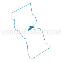
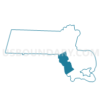
Freetown Precinct 1, Bristol County, Massachusetts
About
Outline

Summary
| Unique Area Identifier | 593839 |
| Name | Freetown Precinct 1 |
| County | Bristol County |
| State | Massachusetts |
| Area (square miles) | 7.15 |
| Land Area (square miles) | 6.95 |
| Water Area (square miles) | 0.21 |
| % of Land Area | 97.10 |
| % of Water Area | 2.90 |
| Latitude of the Internal Point | 41.79751670 |
| Longtitude of the Internal Point | -71.07209060 |
Maps

Graphs
Select a template below for downloading or customizing gragh for Freetown Precinct 1, Bristol County, Massachusetts


Neighbors
Neighoring Voting District (by Name) Neighboring Voting District on the Map
- Berkley Precinct 1, Bristol County, MA
- Fall River Ward 9 Precinct B, Bristol County, MA
- Fall River Ward 9 Precinct C, Bristol County, MA
- Freetown Precinct 2, Bristol County, MA
- Lakeville Precinct 1, Plymouth County, MA
- Voting Districts not defined, Bristol County, MA
Top 10 Neighboring County Subdivision (by Population) Neighboring County Subdivision on the Map
- Fall River city, Bristol County, MA (88,857)
- Lakeville town, Plymouth County, MA (10,602)
- Freetown town, Bristol County, MA (8,870)
- Berkley town, Bristol County, MA (6,411)
Top 10 Neighboring Place (by Population) Neighboring Place on the Map
Top 10 Neighboring Elementary School District (by Population) Neighboring Elementary School District on the Map
- Lakeville School District, MA (10,602)
- Freetown School District, MA (8,870)
- Berkley School District, MA (6,411)
Top 10 Neighboring Secondary School District (by Population) Neighboring Secondary School District on the Map
- Freetown-Lakeville School District, MA (19,472)
- Somerset School District in Berkley (9-12), MA (6,411)
Top 10 Neighboring Unified School District (by Population) Neighboring Unified School District on the Map
Top 10 Neighboring State Legislative District Lower Chamber (by Population) Neighboring State Legislative District Lower Chamber on the Map
- Ninth Bristol District, MA (44,854)
- Sixth Bristol District, MA (37,581)
- State House Districts not defined, MA (0)
Top 10 Neighboring State Legislative District Upper Chamber (by Population) Neighboring State Legislative District Upper Chamber on the Map
- First Plymouth & Bristol District, MA (170,671)
- First Bristol & Plymouth District, MA (163,123)
- State Senate Districts not defined, MA (0)
Top 10 Neighboring 111th Congressional District (by Population) Neighboring 111th Congressional District on the Map
Top 10 Neighboring Census Tract (by Population) Neighboring Census Tract on the Map
- Census Tract 6161, Bristol County, MA (6,411)
- Census Tract 6171.01, Bristol County, MA (4,681)
- Census Tract 5401.03, Plymouth County, MA (4,249)
- Census Tract 6421, Bristol County, MA (4,144)